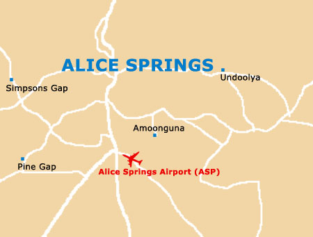
Alice Springs Airport (ASP)
City Orientation and Maps
(Alice Springs, Northern Territory (NT), Australia)
The town of Alice Springs is situated in the very heart of Australia, in the state of the Northern Territory. Surrounded by scenic countryside, national parks and outback areas, Alice Springs is close to a number of important locations, such as Bond Springs and the Alice Springs Waterhole to the north.
Other areas of interest include Undoolya to the east, and Simpsons Gap to the west. Much further away, the world-famous Ayers Rock, known locally as simply the 'Uluru', stands approximately 450 km / 270 miles from the city centre and can be reached by heading in a south-westerly direction, with good roads and sign posts along the way.
Alice Springs Airport (ASP) Maps: Important City Districts
Central Alice Springs is fairly compact and consists of a uniform gridwork which is only five streets wide. The centre is sandwiched between both the Stuart Highway and the Todd River, which remains dry throughout the majority of the year.
Todd Street is an important part of the centre and contains a good selection of shops and eateries, leading to both Wills Terrace and Gregory Terrace, which is home to the office of the Central Australian Tourism Industry Association. Here you will find plenty of tourist information, including maps and brochures about the region's main sights, the free 'Visitors Guide' and also the 'Welcome to Central Australia' leaflet. Attractions close to central Alice Springs include Desert Park to the west, Anzac Hill to the north, and the Olive Pink Botanical Gardens to the east.
Australia Map

Alice Springs Map